Environment Agency: Satellite images confirm absence of natural water damming prior to Shovi disaster
We have acquired high-resolution satellite images, confirming there were no signs of any natural water damming in the valley before the disaster, the National Environment Agency announced.
The agency clarified that glaciological and rocky avalanche processes are complex in nature, and it is impossible to determine the exact time and place of the collapse of rocky and glacial masses.
“In its initial report, the National Environmental Agency explicitly stated that there was no congestion in the Bubisskali River valley before or during the disaster. The agency confirmed this through observations of the water level at the confluence of the Bubisskali and Chanchakhi rivers. Even while preparing the preliminary conclusion, our specialists continued to analyze various data. High-resolution satellite images confirmed the absence of natural water damming in the valley before the disaster. This again shows how important it is to evaluate the issue by specialists and then talk to the public.
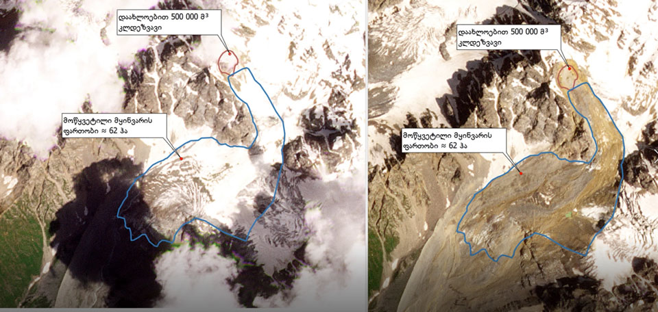
Detailed satellite data analysis reveals the collapse of a rocky mass of approximately 500,000 cubic meters in the Bubisskali River valley, west of the Buba glacier. The rock avalanche led to the rupture of a glacial mass, spanning about 62 hectares, releasing subglacial waters (ongoing studies aim to determine the water volume). These findings reaffirm the assessments in the agency’s initial report, highlighting the complexity of the disaster and the impossibility of predicting it. Due to the multitude of factors influencing the collapse of rocky and glacial masses, determining the exact time and location is impossible. Meteorological data did not show high-intensity precipitation in the valley.
It’s important to note that the early warning system encompasses advanced forecasting for heavy precipitation, hail, strong winds, drought, floods, and flash floods. As for the glaciological and rocky processes developed in the valley, as mentioned, predicting their occurrence is impossible,” stated the National Environment Agency.
The agency issued the initial report on the Shovi disaster’s causes on August 6. The report highlights that “several factors contributed to the rapid development of a complex natural event, which is practically impossible to predict anywhere in the world”. The report suggested that mudflow would have likely reached the cottages within 8-10 minutes.
On August 3, a landslide occurred in Shovi, resulting in the reported death of 21 individuals and ongoing search efforts for 12 people in the disaster area.